
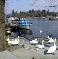
Bowness bustles with shoppers and with people hurrying to join one of the queues to take a trip on Windermere. Here you can see children, and parents, feeding the gulls and stroking friendly swans who have learned to poke into bags for food. For those looking for a quieter part of the village, a stroll round Cockshott Point and Bowness Bay is recommended. It is suitable for all, especially those with restricted mobility.
Bowness, on the east shore of the lake, dates from the 11th century and, for several hundred years, was just a hamlet with a few fishermen's huts and cottages. After the coming of the railway, lodging houses for visitors were constructed and wealthy mill owners built luxurious dwellings.
Opposite the steamer piers stands the grand, cream-painted Belsfield Hotel, once the home of H.W. Schneider, the iron magnate, who bought it in 1869. Each morning he departed from his own special pier and crossed the lake using his steam launch Esperance. He was preceded to the launch by his butler, carrying his breakfast (on a silver salver), which he ate on board. He then joined a train at Lakeside for his Barrow office, using his own railway.
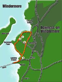
1/ Park in Glebe car park (grid ref. 398966) where there are free parking bays for those with restricted mobility. This lies on the on the other side of the road, from the lake. It is on the one-way circuit and is approached along the shore road continuing south-west beyond the steamer piers. There are no disabled facilities here. From the far end of the car park, cross Glebe Road, with care, to take a wide track signed, Leading to Cockshott Point'. Continue below trees to reach a wrought iron gate, to the left of an access route to a house. The gate is suitable for a pusher to manipulate but a person using an electric wheelchair might find it a little difficult to reach the catch before and after passing through.
2/ Beyond, carry on along a continuing track that can be muddy after rain. The way passes below some redwood trees and across fine parkland. As you progress, climbing a little, look right over a sloping green area, and then the lake, to see the Round House on Belle Isle, now restored after a disastrous fire in 1994. The track now goes on a little above the waters of the lake, where many birds idle, and you will want to pause to enjoy the view. In the tiny bay you can see a myriad of multi-coloured boats anchored, with people working on board. You can also see, in the distance, the ferry crossing the narrow part of Windermere and also passenger boats travelling up and down the lake. Beyond the next gate (easily negotiable by a wheelchair or a buggy), turn right to walk a good track that passes between boats parked on either side and where there is a small kiosk selling refreshments. Opposite is a toilet block.
3/ Continue up the gently sloping path to turn right along the pavement of Ferry Nab Road, which can be busy in the summer, to continue to the ferry terminal. There is a suitable waiting area, on the other side of the road, from where it is pleasant to watch the ferry plying across the lake. Return along the road and take the left turn through the boat park area. Ignore the gate you came through earlier. Continue along the fenced way with sheep, and sometimes geese, in pastures on either side. Continue on to pass through good gate to join Glebe Road. (If you turn right here there is another toilet, a short way along, on the right.)
4/ Cross the road and ascend the gently rising Rectory Road (virtually traffic free) to pass between a grassy park (The Glebe) on the left and the extensive cemetery on the right. Notice the sturdy, eight-foot high iron turnstile into its grounds. Head on to the end of the road.
5/ Bear left, along the second left, to come to the start of Glebe Road. Here you may wish to visit the Tourist Information Centre, with its gift shop and interactive display section. Carry on below The Glebe using the left hand pavement to continue along Glebe Road. Enjoy more of the glorious views up the lake and also look left to see the interesting shelter' created by Chris Brammall, the renowed Furness architectural metalworker. If you wish to take a peak into the various shops or feed the swans, you will need to cross the road. If not, continue along the left side of the road to continue to the car park.
- Information
Distance: 2 miles Time:1-2 hours Terrain: See text Map: OS Explorer OL 7 NB: Restrictions on space mean that this article provides a general summary of the route. It is advisable for anyone who plans to follow the walk to take a copy of the relevant Ordnance Survey map.


Comments: Our rules
We want our comments to be a lively and valuable part of our community - a place where readers can debate and engage with the most important local issues. The ability to comment on our stories is a privilege, not a right, however, and that privilege may be withdrawn if it is abused or misused.
Please report any comments that break our rules.
Read the rules hereComments are closed on this article