
Travelling out towards Kirkby Stephen, and turning onto the B6259 to Nateby, takes you into the beautiful valley of Mallerstang. Within this valley, and from the surrounding Wild Boar Fell and Black Fell Moss, two becks, Red Gill and Little Grain join forces to form Hell Gill Beck. After flowing gently over the open moorland that is so typical of this part of the county, and over Hell Gill Force waterfall, the beck becomes a fully fledged river..the river Eden. The river, for much the length of the valley, winds alongside the road, both vying for space at the bottom of the valley.
Along this valley lay two interesting pieces of defensive history. The first is the picturesque and history steeped castle of Pendragon. The second is the isolated Lammerside tower. Mallerstang, as with much of Cumbria, was in the past vulnerable to Scottish raids. Hence the number of castles, pele towers and fortified houses, manors and halls.
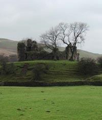
The day I chose started off badly. Looking out of my window at home in Kendal, the mist was low, and the drizzle and showers moved in constantly. Knowing how far I had to drive, and how far up in the Cumbrian hills I was planning to go, it was touch and go as to whether it would be worth my while. At about lunch time, the drizzle had stopped, so armed with camera and tripod, waterproofs and walking boots and maps, I decided to set off. I figured that if I got to Sedbergh, and it was still too drizzly, I'd turn round and come home! As it was, the weather when I passed through Sedbergh was perfect. It was still overcast, but on the whole dry. I travelled along the A683 deciding to visit Lammerside tower first. The route wasn't particularly picturesque due to the low mist and gloom, but with hardly any traffic on the roads it was a relaxing journey. I turned off the A683 to drive down the single track road to Croop farm, that lies at the end of this cul-de-sac. The lonely road wanders over the fells down to the valley floor of Mallerstang. This was the best route I could find, as, not being a walker, it delivered me within a quarter of a mile of the tower. The other route, travelling to Kirkby Stephen and then onto Nateby, would have entailed a good few miles walk along the bridle way. No thank you, especially in this weather!! I finally came to the farm at the end of the roadbut couldn't see any sign of the tower. I parked up, and just as I decided to leave the car, the heavens opened. Just my luck. I decided to have lunch and wait the rain out. Luckily for me, it stopped raining about fifteen minutes later, so I decided to don my waterproofs and set off down the footpath to look for the tower. I hadn't gone more than a few hundred metres, when the tower appeared on the horizon.
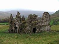
Lammerside tower (sometimes referred to as Castle, sometimes Pele) was built in the 12th century. It was further fortified and strengthened in the 14th century to provide protection against raiding Scots. It lies on a gentle hill side that slopes down to the river. The dull weather and blustery wind, emphasised how isolated and bleak it can be up there! The ruins consist of the tower, now much ruined, and the earthwork remains of buildings to the North and the South. The tower was occupied by a branch of the Wharton family up until the 17th century, when it was finally abandoned in favour of Wharton Hall, the fortified manor house further up the valley. On the whole, the tower is fairly intact, indeed in some places it stands to two storeys high. There are four entrances to the tower, all still standing with their arched doorways. Inside, the tower sports some impressive vaulted ceilings, although due to the amount of roof rubble, the true height of these ceilings can only be guessed at. I took 60 photos of the tower, mainly because it was starting to blow a gale and I was afraid of camera shake producing blurred images. As it was, I only had to discard a few! I love this tower. So much so, that I'll probably re-visit it during the summer to get some better photos of it. At least I know where it is now.
All finished here, I headed back to the car. Ten minutes later and I was turning onto the B6259 to Nateby out of Kirkby Stephen. Next stop, Pendragon castle.
Now.call me obsessed, but I've visited Pendragon castle four times previously! It's just such a fantastic site. The castle is situated about 4 miles south of Kirkby Stephen, the other side of the river to Lammerside Tower. It sits right next to the road, on a mound surrounded by a partial moat. The Normans built the castle in the 12th century, reputedly on the site of a temporary Roman fort. Predating the supposed Roman influence on the area, is the legend that Uther Pendragon, king Arthur's farther founded the site, and along with one hundred of his men, was killed by the invading Saxons when they poisoned the well. There's also a local legend, that has Uther trying to divert the river Eden to fill the moat.but rivers being rivers, it didn't work! What we do know, is that what we see today, was probably built by Hugh de Morville (one of the knights that murdered Thomas A'Becket) in the 12th century. Along with many other local\Cumbrian castles such as Brough, Appleby and Brougham, it then passed to the Clifford family. In 1341, the castle was attacked and badly damaged by fire by a raiding Scottish army. The Cliffords rebuilt it in 1360, and it was occupied until it was again burnt down in 1541. Lady Anne Clifford restored the castle in the mid 17th century, but after her death it fell into disrepair and gradual ruin.
There are parts of the castle that are precariously perched on the mound overlooking the fields and the river below it, but much of it is still solid and in good condition. You can enter the castle up some wooden steps that have been placed there. Once inside, you are stood on about 2 metres of roof rubble (like Lammerside) so you're actually about a floor above the ground level. The castle offers excellent views of the fells and mountains around itideal if you've got a camera with you. I spent about another hour and a half getting yet more photos of the castle. New camera with a zoom you see, so I was able to get some distance shots to add to my collection. The moat is pretty much intact all the way round the foot of the mound on which the castle stands. Walking around the base of the mound, brings you eventually to the river side, perhaps the very spot from which Uther Pendragon attempted his diversion of the river to fill the moat!!
I could go back to Pendragon again and again. It's such a peaceful site, with only the odd walker and sheep to keep you company. One of the more magical castles I've visited, and considering it's only about ten minutes drive from Lammerside, I may just pay it another visit next summer.


Comments: Our rules
We want our comments to be a lively and valuable part of our community - a place where readers can debate and engage with the most important local issues. The ability to comment on our stories is a privilege, not a right, however, and that privilege may be withdrawn if it is abused or misused.
Please report any comments that break our rules.
Read the rules hereComments are closed on this article