
A SOUTH Lakes artist has been 'Tolkienising' the country's national parks, using his map drawing skills.
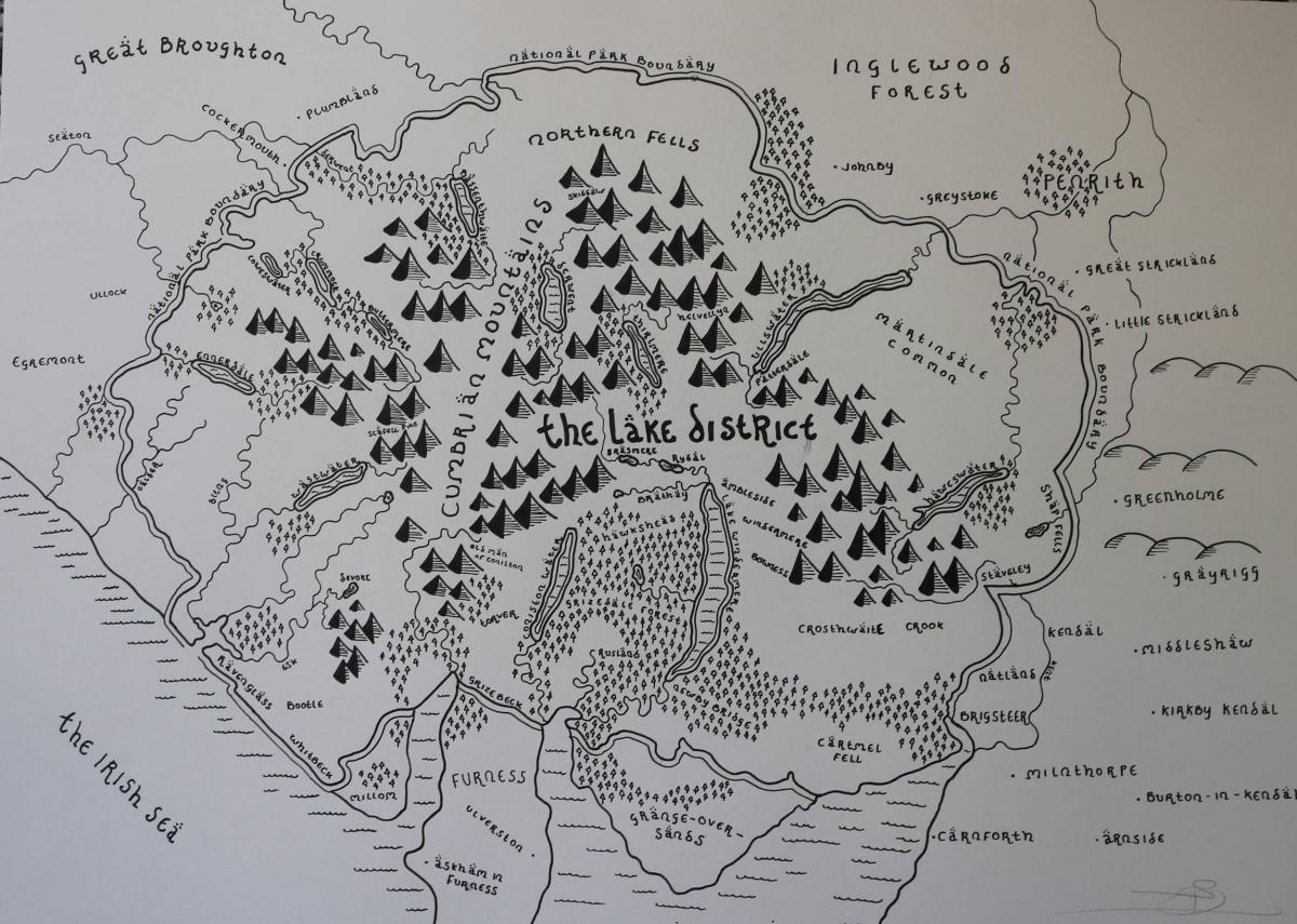
Dan Bell, of Crook, has been taking maps of places including the Lake District and the Yorkshire Dales, and recreating them in the style of J.R.R. Tolkien's hand-drawn maps of Middle Earth published in The Lord of the Rings series.
The Lord of the Rings fan's maps focus on the memorable drawings of mountain ranges, lakes and forests done by Tolkien, making them perfect for replicating national parks.
Dan said: "It started out with me just doodling while I was on the phone, and I realised drawing maps in that style was something that I can do quite well.
"I start out with Ordinance Survey maps, or maps from Google. I piece them together to cover the area I want. Then I draw an outline from that.
"The most distinguishing features about these maps are the natural landmarks: the mountains, forests and lakes. The way Tolkien drew these was very distinctive, so it makes the maps instantly recognisable.
"I've completed the Lake District, Yorkshire Dales and Peak District, and I have been getting commissions from people to do other places as well. I recently did British Colombia in Canada.
"The idea is that people who like maps can have a personalised one, and they can frame it and hang it on a wall."
Dan, who is also a Biologist who has just finished his masters at Imperial College in London, is selling prints of the hand-drawn maps and taking commissions via his page on crafts website Etsy.
Tolkien's maps were published within copies of his fantasy epic The Lord of the Rings to help readers visualise the vast fictional landscapes the author dreamed up.
He drew them himself, contributing to a mammoth creative opus that also saw him create languages.
Dan's works can be found on MiddleEarthsMaps on Etsy.com.
He has already sold more than 100 maps.


Comments: Our rules
We want our comments to be a lively and valuable part of our community - a place where readers can debate and engage with the most important local issues. The ability to comment on our stories is a privilege, not a right, however, and that privilege may be withdrawn if it is abused or misused.
Please report any comments that break our rules.
Read the rules here