
The Greenways scheme was set up by the Countryside Agency to provide off-road routes for the use of walkers, disabled people, wheelchair users, families with pushchairs, cyclists and horse riders.
The first Greenway in Furness was opened on Walney Island in 2000 and I wrote about it in the Leisure' walks page late in 2006.
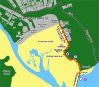
Westfield Greenway, the subject of this article, runs from the Concle Inn, at Rampside, to Barrow. The first part follows the route of a branch of the old Furness Railway Company and is therefore level and very easy for all users. After a sharp left turn, it climbs gently to Westfield Point before descending steadily to continue on towards Barrow. Wheelchair users will need a steady pusher for this part.
From Ulverston, take the A5087 coast road. Leave your vehicle in the parking area less than half-way along the causeway to Roa Island, grid ref 234656. This lies at the start of the Foulney Island spit.
1/ Cross the road from the parking area and continue inland along the pavement. As you near the Concle Inn take the tarmacked path on the left and wind round left to walk the wide tarmacked way. Go left round the barrier and carry on along the hedged way, with lots of bird-song coming from the bushes. Walk on to reach an intriguing gate. It is easy for pedestrians to pass through but wheelchair users and walkers with large buggies will need to lift the middle prong out of its socket to make the passageway wider so that they can go on. This type of gate is used to exclude prohibited vehicles from the Greenway. Head on along the level smooth way, where sheep graze the rolling pastures of Beacon Hill to your left. At the Greenway signpost, you can see the continuing outline of the old railway track, raised a little above the surrounding fields, and away to your right you can just spot the tower of Rampside church.
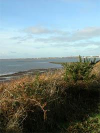
2/ Follow the track left beside the remnants of a once fine turf wall, with a stream and pools beyond, where ducks dabble and a pair of swans feed. Then the track slants uphill to a headland. There are two seats on the way up the gentle slope, where you can take a short break and just enjoy the sun and from where there is a great view of the Roosecote Sands. Look left to see Roa Island with dramatic Piel beyond. Along the skyline is Walney beyond Piel Channel. Continue to the brow.
3/ Pause before you start a gentle descent to Westfield Point. Ahead, over the bay, lies Barrow, spread out before you; the Town Hall, with its clock standing tall. A little to its left is the vast white Submarine Hall. To your right are the three gas terminals, - sound dull but many users of the Greenway will find their legoland' appearance fascinating. Look for the pipe with its gas flame burning boldly. Beyond the gas terminals you can view the power station and then the docks with their myriad of cranes. The sewage works lies between the two. Perhaps you will enjoy passing the terminals and the power station but prefer to return before you reach the treatment works.
4/ Carry on along the now level way for as far as you wish. If the tide is out look for waders along the sandy shore. On your return, and just before you ascend the slope at Westfield Point, look right to see Ridding Head Scar, stretching seawards. Here you might spot oystercatchers and dunlin. Continue on through the two gates and the barrier to return to the Concle, where you turn right for the parking area.
Information
Distance: From beginning to end two miles one way.
Time: One hour one way.
Terrain: Ideal surface for those people with limited mobility. Two pushers for the little hill climb would help.
Map: OS Explorer OL6.
Refreshments: Concle Inn, Clarke's at Rampside and bistro at Roa.
Public Toilets: At the near edge of Roa Island with disabled facilities. Alas on my last visit the Gents door had been vandalised and it was impossible to open. All the group had to use the Ladies - with a lookout!
NB: Restrictions on space mean that this article provides a general summary of the route. It is advisable for anyone who plans to follow the walk to take a copy of the relevant Ordnance Survey map.


Comments: Our rules
We want our comments to be a lively and valuable part of our community - a place where readers can debate and engage with the most important local issues. The ability to comment on our stories is a privilege, not a right, however, and that privilege may be withdrawn if it is abused or misused.
Please report any comments that break our rules.
Read the rules hereComments are closed on this article