
Enjoy a peaceful walk to Kentmere Reservoir then back along the other side of the valley exploring the River Kent from near its beginning and 500 feet of its hurried descent.
Along the way you pass an assortment of industrial and agricultural heritage, passing through each of Kentmere’s medieval “quarters”.
The name Kent is probably derived from an old British or Celtic word cunêtio, meaning sacred river. This is one of 67 walks in volume 1 of John Edmondson’s book, “Walkbase Kendal”.
Kentmere Reservoir Circuit
Route Description
1. Walk northwards along the road towards Kentmere and after a mile bear right onto Lowfield Lane. Follow the lane as it bends left and then right through the hamlet in Green Quarter and continue up High Lane. 250 yards after passing the junction with Hellwell Lane on the left branch off to the left onto a signed bridleway.

Kentmere Reservoir Circuit
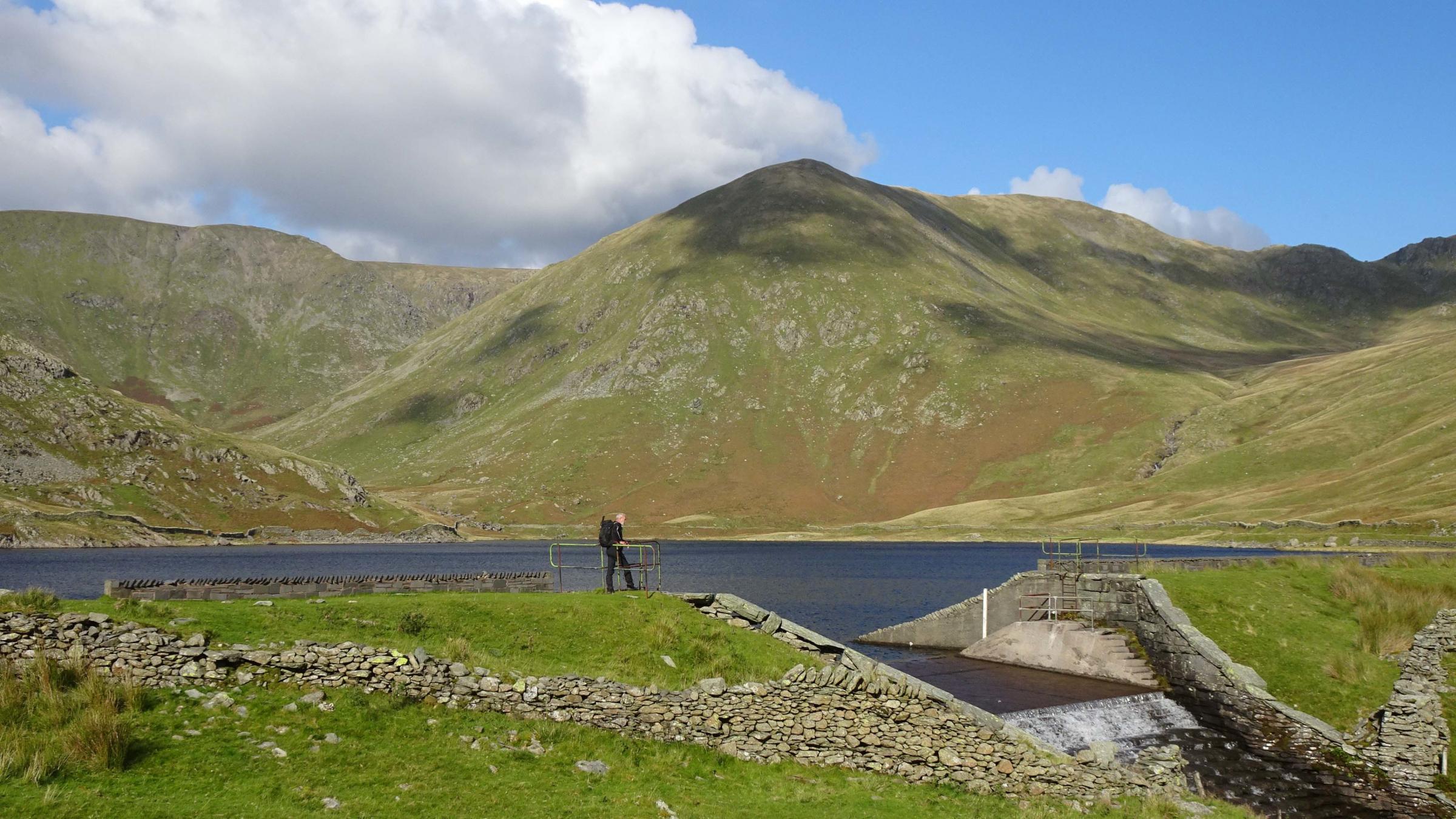
2. Follow the walled lane and bear left at the bridleway junction signed Mardale then keep left to walk alongside the wall on the left. Go through a gate and turn left at the end of the tarmac lane. Bear left onto the footpath signed Kentmere Reservoir. At Tongue House, the path goes through two gateways past a barn. Follow the path to the left of quarry spoil heaps and head for the right of the reservoir dam.
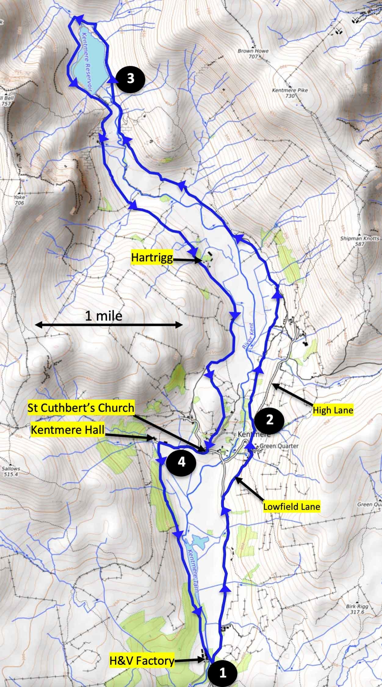
Kentmere Reservoir Circuit
3. Walk along the edge of a disused water channel on the east side of the reservoir. Where the channel ends continue ahead and cross Lingmell Gill on the line of a wall. If the ground is boggy and the Gill full it may be necessary to head uphill to find a safe crossing. Return to the wall on the left then follow the bank of the River Kent to identify a safe crossing point. Cross the river then head uphill to meet a path going southwards along the west side of the reservoir. Follow the track past the dam and Reservoir Cottage to Hartrigg, where the route joins a tarmac lane. After passing Scales the lane goes around Calfhowe Crag and across a cattle grid. Turn left onto the signed path (the second after Scales). This delightful grassy walled path ascends a low hill, descends to Kentmere and joins a path to St Cuthbert’s church.
4. Turn right then in front of the church keep left onto Hodgson Brow and descend towards Kentmere Hall. Turn left to go through a gate onto the footpath that crosses a field, goes alongside Hall Gill on the right, then through a gate to cross the Gill via a concrete bridge. The path ascends through Hall Wood. Keep left at a junction and follow the track above the right of Kentmere Tarn. During the 20th century, black sludge was dredged from the tarn to extract diatomite, used to make filtration media, toothpaste and TNT. An aerial ropeway used to carry a chain of buckets from the tarn to the factory. In 1942 they also dredged up an iron Viking spearhead and in 1955 a 10th century Viking dugout canoe was recovered. After passing the tarn the path goes through the factory premises. Hollingworth and Vose now manufacture fabrics for face mask and ventilator filters, and other nonwoven materials used to make surgical hoods and consumables for Covid test systems. At the end of the factory buildings turn left, cross the road bridge and return to where the walk began.
Walk factfile
Distance: 10.5 miles (17km);
Ascent: 1600 feet (500m); Time: 5 hours
Terrain: Stony lanes, grassy footpaths, rough fell, quiet roads
Map: Ordnance survey OL7
Start: Unmade layby on road to Kentmere, south of Hollingworth and Vose factory entrance.
Map ref. NY 456 019 169, postcode LA8 9JJ


Comments: Our rules
We want our comments to be a lively and valuable part of our community - a place where readers can debate and engage with the most important local issues. The ability to comment on our stories is a privilege, not a right, however, and that privilege may be withdrawn if it is abused or misused.
Please report any comments that break our rules.
Read the rules here