
I enjoyed this easy stroll of around four mniles in early November, following the first flurry of snow on the high hills. There have been reports over the last few weeks of wintering birds arriving early in the face of arctic conditins in the far north of Europe.
Those of us who love walking have to ignore the weather to some extent but the higher routes should be avoided unless you are more of a mountaineer than a stroller. On all occasions, however, you should dress properly to suit the conditions.
So off I went, in the face of wind and rain, to do this circuit of Rydal Water in pursuit of wintering birds and I was not disappointed.
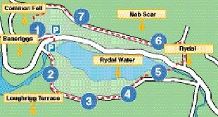
How to get there Follow the A591 from Ambleside towards Grasmere. At Rydal there is a large car park on each side of the road at White Moss Common. This area is splendidly maintained by the National Trust. All walkers have long had cause to be grateful for the work of this institution.
Map: OS OL7 Grid reference: 346 064 Length: About 4 miles.
Time: Allow three hours to allow for plenty of wildlife watching.
Refreshments: There is a wide range of outlets in both Ambleside and Grasmere, as well as at the Rydal Hotel. There are, however, lots of sheltered spots on the route which are ideal for a picnic.
Route 1 From the upper car park at White Moss, cross the A591 and descend to the River Rothay and cross the wooden footbridge over this lovely water-course. On the day of my visit, the heavy rain was swelling the Rothay to a more-than-impressive torrent. Despite this, the birdlife was coping well as it always does, and I watched dipper and heron, plus a flock of 12 goosanders riding the current like an ancient galleon in full sail.
2 A steep incline then leads to a level area known as Loughrigg Terrace. You can look down at this point to Rydal Water. I have walked this in all seasons of the year, but this was a stormy scene. I could see a few sheltered spots, where there were flocks of roosting Greylag geese and some 22 Whooper swans. The presence of the latter was a sure sign that the Arctic weather had already driven them south to the comparative warmth of Britain.
3 The obvious route continues ahead to reach Rydal Caves, which were created as a result of extensive slate mining in the area. It is difficult to imagine that at one time the Lake District was at the hub of the industry of northern England and here there was mining, quarrying and iron smelting.
4 The track now descends from the slate quarry area where I was able to shelter from the wind, rain and sleet and enjoy a hot coffee and a sandwich. The route approaches the shore of Rydal Water and enters a delightful area of deciduous trees. As I reached this sheltered area, the rain had abated and I had a glimpse of pale sunshine, but dark clouds were still being swept along by a strong wind approaching gale force.
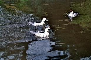
5 Passing through the woodland, approach a substantial footbridge crossing the Rothay. This leads up to the A591, which is crossed. Do not rush this, but take the time to enjoy the riverside scenery. The flock of goosanders which I saw earlier had found shelter in a deep pool and were diving for fish. They are known as saw-billed ducks and have bills with serrated edges ideal for keeping hold of slippery fish. Then I had a surprise. I saw three little sawbilled ducks called Smew and this is the first time in more than 50 years that I have seen them in Cumbria. They are much more common in the south of England.
6 Cross the road and find a narrow road close to the Rydal Hotel, leading up to Rydal Mount, which is one of the most important literary locations to be found in Britain. This house was the last home of William Wordsworth and it is well worth an extended visit, when open. Here is Dora’s Field, which was the inspiration of his poem Daffodils and the gardens of the house follow the design of the gardens laid out by the great man himself.
7 At this point, follow the substantial track still known locally as the Coffin Road, or Corpse Road. This was the old track linking Grasmere and Ambleside where there were churches. The dead were carried to their last resting place and, at regular intervals, there are slabs of flat stone on which the bearers could place the box while they enjoyed a well-earned rest. From here, there are panoramic views of Grasmere and Rydal Water and finally there is a steep descent to return to the White Moss car park. As I arrived at my car, the rain had stopped and the sun was shining. Talk about bad luck!
NB: Restrictions on space mean that this article provides a general summary of the route. It is advisable for anyone who plans to follow the walk to take a copy of the relevant Ordnance Survey map.


Comments: Our rules
We want our comments to be a lively and valuable part of our community - a place where readers can debate and engage with the most important local issues. The ability to comment on our stories is a privilege, not a right, however, and that privilege may be withdrawn if it is abused or misused.
Please report any comments that break our rules.
Read the rules here