
ONE of my favourite walks in the whole of Cumbria is around Alston – loved by serious walkers but under-rated by those who prefer to ‘stroll’.
The little town, with its historic market centre, is set in spectacular countryside, which causes tough long distance walkers to drool.
The route followed here, however, is quite gentle and meanders through deciduous woodlands and alongside the splendid River Nent with its waterfalls.
The industrial archeology in the area is also fascinating.
To get there, leave the M6 at Junction 40 and follow the A686 signed to Hexham. The road is narrow and twisting so care does need to be taken. It climbs to more than 1,500 feet so be sure of a clear day.
As the A686 passes through Alston look for a sign to the narrow gauge railway where there is parking. This is the start point.
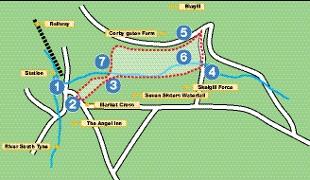
1. Start from the Railway car park. The line was once a standard gauge route linking Alston with Newcastle but this closed in 1976. Eleven years later volunteers developed a narrow gauge route down to Kirkhaugh. The return journey takes about an hour and passes through spectacular scenery into the South Tyne River. Turn left from the railway and follow the road up into the town, which is built upon a steep slope. Pass the tourist information centre and the church of St Augustine on the right. Opposite the church is the Angel Inn.
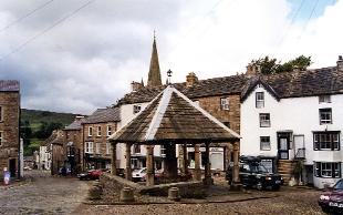
2. Continue uphill to reach the canopied market cross and a fire structure to celebrate the fact that, at a altitude of more than 1,000 feet Alston is the highest market town in England.The market cross was built in 1765 with money provided by local man William Stephenson, who made a fortune large enough to become Lord Mayor of London. The area was restored in 1883 and again in the 20th Century when runaway lorries crashed into it. The original memorial stone is now on display in the parish church.
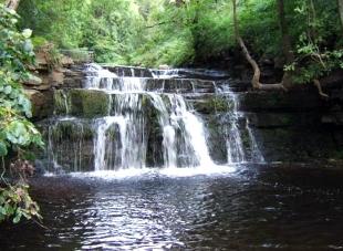
3. From the market square turn left through a network of narrow sloping streets lined with former shops and cottages. Find a sign to the right indicating Gossipgate. We can only speculate as to how this place got its name. Before a bridge turn right and follow a footpath passing the seven sisters waterfall. Alston is so steep that there are several dramatic waterfalls along the River Nent, which is a major tributory of the South Tyne. The whole of this street is lined with trees while views up to the left reveal terraced fields dating back to Anglo-Saxon times. The route is obvious and passes across a bridge over a small stream through stiles and over fields to one of the best waterfalls in the area. This is High Nent Force.
4. When you come to the road leading to Blagill turn left over a bridge and look to the right for the side of the long disused Blagill lead mine. The road then climbs steeply into Blagill village where the 17th Century cottages were the homes of families who made there living from farming and lead mining.
5. From the village turn left and follow field paths. There are field gales and all the local farmers ask is for walkers to close them and keep to obvious tracks.
6. Pass Corbriggate farm to the right. There are deeds for the property dating to 1279, when the settlement was on the main road between Alston lead mines to Newcastle via Corbridge. This was on the old packhorse route with the leading horse carrying bells to warn people that the ‘train’ was passing through.
7. Turn right at a bridge and then left towards Alston. The Gossipgate footpath leads into the old stable yard of the Angel Inn. Pass through the entrance and turn right. Descend to the station and start point.


Comments: Our rules
We want our comments to be a lively and valuable part of our community - a place where readers can debate and engage with the most important local issues. The ability to comment on our stories is a privilege, not a right, however, and that privilege may be withdrawn if it is abused or misused.
Please report any comments that break our rules.
Read the rules here